Early Christianity in Western Normandy

I’ve not really written much about my archaeological research on this blog so far. However, I’m getting ready to head of to Normandy in a few weeks to do a small-scale pilot project on early Christianity in the area (thanks to a grant from the Society for Medieval Archaeology), so I thought I’d include a little bit about my current plans (ie I’ve basically cut and paste a chunk from the grant proposal)

Mapping the early medieval church in Western Normandy: AD400-1200

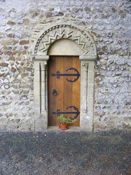
This project aims to begin mapping the evidence for Christianity in Western Normandy using archaeological and architectural evidence to supplement the sparse documentary material, with a view to developing a better understanding of the evolution of the Church in this understudied region. The Cotentin peninsula (forming the bulk of the modern Département of Manche- roughly coterminous with the diocese of Coutances) was a border region throughout the early medieval period. Whilst the initial evangelisation of the area was carried out in the late period by the bishops of Coutances (the Roman town of Cosidia) it is clear that the early church in the area was strongly influenced by missionary activity from Brittany and Ireland; for example, the monastery at Orval may have been founded by Columbanus. From the 9th century the area saw considerable political disruption following extensive Viking raiding and then settlement along its northern and western coast. The political and social unrest this caused saw it fall under the first the political control of the Kingdom of Brittany and then the Duchy of Normandy, though it was physically and politically peripheral to both polities. The ecclesiastical structure saw extensive disruption in the later first millennium; the see of Coutances fell into abeyance in 866 following Viking attacks and was not re-established fully until 1049. The politically peripheral nature of this area and the impact of Vikings mean that documentary evidence for the region before the 12th century is sparse and consists mainly of sources from outside the area. Any attempt to reconstruct the nature and development of the early church thus has to be able to fully integrate the archaeological and architectural evidence (cf Jarry 1998). Pre-Romanesque religious structures are known Querqueville and Portbail (Duval 1995), and a series of Christian Merovingian cemeteries are recorded in the antiquarian literature (Pilet-Lemière & Levalet 1989). However, existing scholarship on the 11th and 12th century churches in Normandy has generally focused on high-status and archaeologically elaborate structures (e.g. Mussett 1967: Grant 2005), particularly within the Norman heartland, east of the River Orne. There has been virtually no research into the survival of early fabric in the parish churches (though see Baylé 1999). However, recent field visits by the PI to the region have made it clear that early fabric does survive in many parish churches. Distinctive features include the use of herringbone masonry, petit appareil and round headed monolithic windows. A number of grave slabs of probable early date have also been identified.Research objectives. The aim of this project is through a combination of desk-based research and fieldwork to map the evidence for the early church in the Cotentin, allowing the study of the development of the religious life in the region to move beyond the limitations of the documentary evidence. The work will address the following questions:
i) How much evidence is there for Merovingian religious activity on later church sites?
ii) How was this activity structured? Was it centralised and limited to a small number of monastic sites or is ecclesiastical provision more decentralised?
iii) Can this be used to assess the extent to which Viking settlements really disrupted ecclesiastical activity in the region?
iv) To what extent does Romanesque and pre-Romanesque fabric survive in existing church structures?
v) How can this evidence be used to understand the development of the ecclesiastical organisation in the region following its integration into the Duchy of Normandy in the 11th century?
vi) To what extent can archaeology be used to explore the development of the church in an area with limited contemporary documentary evidence?

Methodology
The limited historical resources will be used to build up a corpus of contemporary references to churches in the region, which will be complimented by collating the archaeological evidence, mainly from 19th and early 20th century French journals (available in the UK at the British Library and Bodleian Library, Oxford). The fieldwork element of the project aims to map the extent of surviving Romanesque and pre-Romanesque fabric in the existing churches in the area. This will involve two phases of fieldwork. Phase I will comprise field visits by the PI to all churches within two sample areas: an area to the west of Coutances and an area in the far north-west of the peninsula (La Hague). The study areas have been selected to provide contrasting social, political and economic backgrounds in the study period, and to avoid areas of the region, which saw a high level of destruction of churches during the 1944 Normandy landings. Key features will be recorded by digital camera. No permissions are required at this stage.

Phase II consists of more detailed investigation and analysis of a smaller number of structures, selected on the basis of the results of Phase I. This will involve creating a more detailed drawn written and photographic record by the PI and a Research Assistant using a digital SLR camera, hand survey and some photo rectification. Analysis will define key phases of work and seek to identify and interpret early fabric. Once the physical evidence and textual evidence for the early church has been mapped, it will be used as a basis for an attempt to write an overview of the growth and structure of religious activity in the region. Permissions maybe needed depending on sites chosen; will be sought if necessary on completion of Phase I.

Folk Against Facism

A rather depressing but perhaps inevitable story about attempts by the BNP to co-opt folk music to the fascist cause. Traditionally, the sound track of the far right has been heavy rock/punk e.g. Skrewdriver). However, as the article points out this is not compatible with the new smooth image the BNP are trying to put across now. This has been reported a number of time previously- see here and here. However, there is now the formation of a new body Folk Against Fascism to try and counter the attempt by the BNP to ‘claim’ folk music as its own (interestingly on its on-line shop the BNP labels it ‘British’ rather than ‘English’ folk music). Now of course, I doubt this is exactly going to leave Nick Griffin quaking in his hush-puppies; but its an extremely useful development, if only to remind the Neanderthals in the BNP that the English (and indeed Irish and Scottish) folk tradition is primarily an anti-establishment one, pitted against landed and industrial wealth and imperialism. Its not surprising that ideologically bankrupt and historically and culturally ignorant parties such as BNP should in its typically half-arsed and lazy way try and annexe folk music, and its pleasing to see that those involved in the current folk scene are busy telling them precisely where to stick it.

From dots to downloads

By pure chance I caught a fantastic programme on the Radio this morning called From Dots to Downloads about the rediscovery of tunebooks of 17th to 19th century date. These were private notebooks containing a range of music including traditional folk music compiled by local musicians for their own private use. It was presented by Tim van Eyken. The programme particularly talked about the wonderful Village Music Project. Its worth adding that this is not the only excellent resource on-line which brings folk music resources to the wider public. Its definitely worth checking out the excellent FARNE (Folk Archive Resource in the North-East). I was also pleased that it mentioned the importance of folk music to the work of the poet John Clare, a favourite poet of mine (not to mention potentially an ancestor…)

Mining heritage

Last week Durham saw the annual Durham Miner’s Gala: this year it attracted over 100 000 people to the city to remember the grant tradition of mining in Durham. This year numbers were doubtlessly swelled by the fact that it was 25 years since the miner’s strike of 1984. The narrow streets were crowded with brass bands from the surrounding mining villages marching along the banners from the local National Union of Miner’s lodges. Its an awe-inspiring and moving occasion. However, the elephant in the room (or at least in the streets) is the sad fact that there are now no working coal mines in Durham or indeed the entire north-eastern coal field.

When I was doing A levels, it was common knowledge that the north-east (County Durham and Northumberland) was dominated by coal mining. Even then (in the late 1980s) it was notable that we covered this more in History than in Geography. The process of de-industrialisation may have reached a bloody climax in 1984, but mines had been shutting long before this. So when I started working in Durham and Northumberand a little under a decade ago it was no surprise to me that there was little active mining in the area. What was a shock though was the way the entire industry had been wiped from the landscape. Today, the only pitheads still standing are heritage attractions (at Beamish, Washington F Pit and Woodhorn). I was used to the former industrialised areas of Yorkshire such as Leeds, Bradford and Sheffield, where although many factories and mills were no longer working, the buildings themselves still stood. However, in the north-east the entire infrastructure of a globally significant industry that more or less underpinned entire sections of the regional culture has been entirely erased. It was not only the removal of all the mine buildings that is staggering, but the shifting of the spoil heaps. The spoil pit for the pit at Ashington was once the biggest manmade mound in Europe; its now entirely disappeared. Once in the course of work I came across some photographs of the Durham landscape in the 1950s. There many pictures of many mining villages I knew quite well, but they looked almost entirely unfamiliar because in the background were the spoilheaps standing high above the buildings. The end of the mining industry did not just mean the destruction of the mines themselves but an entire reworking of the landscape itself. I was told recently about the notion of the Anthropocene used to describe the period of earth’s geological history when for the first time human’s rather than natural processes began to influence the earth’s geology and geomorphology. The mining history of Durham is surely a case study in this. Now, though, there is clearly a growing interest in reminding people of the role mining played in County Durham. I think people are realising that babies born during the strike are now in their mid-20s, but have never known the county has a centre for coal production. The Gala, which nearly died in the late 1980s, is now bigger than ever (it’s still the biggest regular political rally in the world). Almost all former pit villages have now erected memorials to their collieries. There is a burgeoning interest in oral history and local history; new banner’s for the Gala are even being created. Despite all this enthusiasm, there is still a strange and silent gap where the mine’s themselves used to be.

There is also a political element to this. I’ve been told that following the ’84 strike, English Heritage wanted to record the historic buildings and installations linked to the mines that were to close. Apparently, however, Michael Heseltine (President of the Board of Trade at the time) actively forbade this; it is hard not to see this as a vindictive act against the miners. The feeling that the mining industry should not be turned into a heritage resource was not, hoewever, simply promoted by the government. Many miners at the time felt strongly that what they saw as a living industry should not be turned into a heritage or tourist attraction. For them the wounds were fresh and the bitterness too raw. Consequently, it is not surprising at the time there was little appetite for protecting or preserving the pit heads.

Return to Doggerland

After my blog earlier about drowned lands, I though the following was quite nicely timed.

BBC Radio 4 Open Country programme explores Doggerland.
http://www.bbc.co.uk/programmes/b00lmpkb

On the first day of this year’s Festival of British Archaeology, BBC
Radio 4 will be airing a special programme exploring Europe’s lost world
– Doggerland – a land lost beneath the waves of the North Sea, which is
the focus of a recent book published by the CBA.

Besides speaking to archaeologists who are investigating Doggerland,
Helen Mark will be joined by the storyteller Hugh Lupton who imagines
the myths of those long-lost hunter-gatherers.

The programme will be aired as follows:

* BBC Radio 4 on Saturday 18th July at 6.00am
* repeated on Thursday 23rd at 3.00pm
* will be on the BBC iPlayer for quite some time after that date.

For more information about Doggerland or to purchase a copy, see the CBA
news release about Europe’s Lost World; the rediscovery of Doggerland:
http://www.britarch.ac.uk/news/090327-doggerland

I’m particularly pleased as I’m a fan of Hugh Lupton, not least because of the wonderful work he’s done with Chris Wood.

Binchester landscapes

I went exploring the environs of Binchester last week. Primarily I was interested in getting a feeling for the extent that there might be surviving Romano-British field archaeology in the area that surrounded the fort. Whilst I did find some interesting features, it was also a fascinating exercise in the exploring a post-medieval and modern landscape. Most of the fields appear to be a product of 18th or 19th century parliamentary enclosure, although there are areas of ridge and furrow in many of the fields. I’m intrigued by possible areas of what appear to be ridge and furrow in the low-lying area around the Bell Burn, but these can’t be medieval ploughing can they? More likely they are linked to the management of water meadows. The woods along the Bell Burn are probably ancient woodland and are rich in birch and sycamore, although there are clearly many features within them. There are a series of leats and small stone bridges linked along the course of the stream. These are probably post-medieval and perhaps connected with a lot of investment put into the lands owned by the Bishops of Durham in this area in the late 18th century.

Walking through the woods I also stumbled across a recent ‘shrine’ clearly to someone who had died and been remembered by his family at a place he’d loved. It was rather an eerie experience to discover it tucked away in a thick wood. Strangely enough, I came across another similar example a little further on by a bench on the old railway track (now a footpath). Is this a Bishop Auckland tradition?


The railway track was a reminder that this part of Durham was a heavily industrialised area, with many collieries; Lodge Farm just to the south of the wood was once where all the pit ponies in Durham were bred- according to a visitor to site whose grandfather had worked there, there were sometimes thousands of ponies there; I wonder if some of the features along the burn were connected to the need to water them?

Drowned Lands

Last week we took the nipper down to Hull to visit The Deep (an excellent afternoon out for all those who love combining looking at fish with colossal sensory overload). Afterwards we headed out east into Holderness, the slice of land that lies in between the Humber estuary, the Wolds and the North Sea. This part of Yorkshire feels very like East Anglia, with its low-lying wetlands, shallow coastlines and insistent presence of the North Sea. One of my favourite parts is Spurn Head which juts out into the mouth of the Humber, and has a vaguely post-Apocalyptic feel, and reminds me of places like Dungeness, combining raw nature, ruins and traces of industry. At Spurn you can watch waders feed on the mud flats whilst in the background the lights from the petrochemical factories at Immingham twinkle on the other side of the estuary.

Like much of the east coast, Holderness has been in a constant struggle with the sea. Estimates vary, but its reckoned that between 3 and 4 miles of land have been lost to the North Sea since the Roman period. Villages with evocative names such as Frismersk, Orwith Fleet, Ravenser Odd, Dimlington, Hoton and Turmarr amongst others have all disappeared since the Middle Ages. South of the Humber many other villages have slipped beneath the waves, perhaps the best known being Dunwich in Suffolk, once a thriving coastal trading town, but now largely consigned to the sea (not to be mistaken of course with the Dunwich which appears in the works of HP Lovecraft…). I like the idea of these missing villages and towns lying beneath the waves of the German Sea These are the last traces of the land bridge that once linked Britain the Continent. Along the west coast of Britain, there are myths of other drowned lands, such as Lyonesse (off Cornwall) and Cantre’r Gwaelod (in Cardigan Bay), but, as far as I know, the lost villages of the East coast have never stimulated similar legends. Although there have been fantastic archaeological and geomorphological projects to map these drowned lands, of the North Sea, I like the idea of mapping the lost histories of these drowned villages. It would have to be an entirely speculative and creative exercise, certainly not something rigorous or methodological; perhaps more like a collaborative work of fiction. Something else for the ‘to do’ list.

Road to ruin

One of my first professional archaeology jobs after I completed my undergraduate degree was as a site assistant on an English Heritage fieldwork project along the edge of the A1 (‘The Great North Road’) around Catterick. This involved fieldwalking and excavation on the site of the Roman town of Cataractonium, in advance of a scheme for widening the road to three lanes. My abiding memories of this job are the joys of fieldwalking in light snow cover and digging in shin deep mud.

Little did I know that I would later come to know this stretch of road extremely well. Having variously worked in Northumberland and Durham for the last eight years, I must have now driven up and down this section of the A1 hundreds of times. As it happens the road widening scheme is only now just beginning (a mere 16 years after I was working on the site). What has surprised me is how attached I’ve become to the landscape along the road, including not just the farmhouse, copses and fields, but also the garages and service stations. They’ve all become embedded in my own personal landscape of the commute to work; as such its rather strange to see these private landmarks and distance markers being bulldozed away Its also a shame to see some important aspects of the modern (post-medieval landscape) disappearing. The Great North Road was the main road north from London to Edinburgh since the medieval period, and became particularly important as the route that the mail coaches ran in the 18th and 19th century. It is only with the advent of the railways and more recently the construction of the M1 in the late 1950s and early 1960s that its key role has been circumvented. Even now, it is still the main road north from York to Edinburgh (and once north of Newcastle, is still single carriage way in places).

Its history has meant that it has created its own distinct landscape. Although it now by-passes the centres of most villages and towns, many of which still contain historic coaching inns, many farms still lie close to the road (and at a microtopgrapic level are clearly aligned on it). It’s still crossed by B roads and farm tracks, and in several places former bridges can be seen just beyond the edge of the road. On top of this more ‘historic’ landscape, there is also the post-war infrastructure of a main road, including petrol stations, cafés and service stations. Much of these features are now being sacrificed to the need for a few additional lanes of road. Whilst I would not argue that the Little Chef at Dishforth is of the same historic value as the Roman town at Catterick, it is sad to see the erosion of these elements of an historic landscape. I suspect that there has been little recording of these structures (though I might be wrong).

These ‘modern’ road landscapes aren’t entirely overlooked; Iain Sinclair’s London Orbital explores the M250- the kind of inbetween landscape so loved of the late JG Ballard; there’s also Edward Platt’s Leadville: A Biography of the A40 (a road I spent a lot of time staring at blankly at the Oxford Tube ferried me into London in the mid-1990s. This kind of writing is not even a particularly modern phenomenon: the artist John Piper wrote a long description of the modern and ancient sites along the old Bath Road (A4) as long ago as 1939 (Architectural Review (May 1939), 229-46).

Postscript: a link to the wonderful website Pathetic Motorways

Call for Papers: Archaeology and Englishness

“Field archaeology is an essentially English form of sport” O.G.S Crawford

Theoretical Archaeology Group Conference Durham 2009

As Gordon Brown wrestles with how to promote a sense of ‘Britishness’, there are increased signs of revival of a sense of English identity, whether expressed through the resurgence in popularity of the English flag or increased call to celebrate St George’s Day as a national holiday. There is also an increasing popular literature exploring the notion of the ‘English’ and ‘Englishness’ often creating essentialised models of the concept (e.g. Ackroyd 2002; Gill 2007; Paxman 1999).

However, whilst other discipline, such as art history, literary studies and geography have long treated the notion of ‘Englishness’ as concept worthy of analysis and deconstruction, this has not been true for archaeology (cf. : Burden and Kohl 2006; Corbett , Holt and Russell 2002; Matless 1998; Pevsner 1956). Whether exploring the development of national traditions of scholarship or considering the way in which material culture is used to develop and maintain a sense of national identity, there has been a tendency for England to be subsumed within a wider British or imperial discourse (though there are some exceptions e.g. Johnson 2007). This session aims to restore this balance and consider the extent to which it is possible to recognise the notion of ‘England’ and ‘Englishness’ within archaeology.

It is hoped to explore a number of facets of the problematic relationship between archaeology and English identity including: 1/ Materiality and Englishness: the way in which material culture, structures and landscapes were used to create and maintain a distinct sense of English identity in past societies; 2/ The development of English traditions of archaeological scholarship and a consideration of the consequences of the development of ‘England’ as a distinct unit of analysis. Is there a distinct English tradition of archaeology or heritage management?; 3/ The use of archaeology to create discourses of ‘Englishness’ in popular culture.

Ackroyd, P. 2002. Albion – The origins of the English imagination London
Burden R and S. Kohl 2006. Landscape and Englishness, Amsterdam
Corbett, D., Holt, Y. and Russell, F. 2002. The geographies of Englishness : landscape and the national past 1880-1940 London
Gill, A.A. 2007. The Angry Island: Hunting the English London
Johnson, M. 2007. Ideas of landscape Blackwell
Matless, D. 1998. Landscape and Englishness London
Paxman, J. 1999. The English: A portrait of a people London
Pevsner, N. 1956. The Englishness of English Art London

Scouring the horse

Nice little article about the ‘scouring’ of the White Horse at Uffington. It’s a wonderful site. Although the Wiltshire Downs are better known, I have a soft spot for the Berkshire Downs, particularly the area from the White Horse along the Ridgeway to Wayland’s Smithy and down to Ashdown House (which has also recently appeared in the news). I spent several weeks working for Oxford Archaeology on a very exposed hillside nearby excavating the area where a Bronze Age hoard had been found. I can still remember the way in which the curtains of rain would sweep across the landscape. I would watch the front of the shower of rain move over the field towards me allowing me to time my retreat to the site hut to perfection.